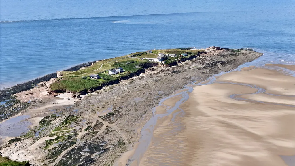
Great Hilbre
Hilbre Island
The largest of the three Hilbre Islands and the main destination for walkers: history, geology, wildlife, visitor facilities and wide Dee Estuary views.
History
The islands were once part of the mainland. Wirral Council’s management plan puts their separation at about 5500 BC and records probable Mesolithic sites from about 5000 BC, left by hunter-gatherers who used flint tools. The Romans visited and left objects such as bronze buckles and pottery, but no structures have been found, and a nineteenth-century suggestion of a Roman lighthouse has no evidence behind it.
Grave remains from the 10th and 11th centuries show a religious presence before the Norman Conquest. In 1140 the island passed to Chester Abbey, which kept a Benedictine cell of two monks and their servants there until the Dissolution in 1538. They ran fishing boats, watched the anchorages and collected West Kirby’s tithes. The chapel was dedicated to St Mary the Blessed Virgin, and from about 1234 parishioners of West Kirby made an annual visit for Mass on 15 August.
From the 16th to the 18th centuries Hilbre and Hyle Lake were an important anchorage as the river at Chester silted up, and troops and horses embarked here for Ireland. Salt was refined on the island in the late 17th and early 18th centuries, and traces survive in the north. A public house is recorded from 1793 for the crews of small vessels. Locally it is remembered as the Seagull Inn, a name that never appears in official records.
Most of the buildings seen today date from the Victorian owners, the Liverpool Docks Trustees, later the Mersey Docks and Harbour Board. They leased the islands in 1826 for a semaphore telegraph station, built the present stone Telegraph Station in 1841 and bought the freehold from Chester Cathedral in 1856. A Trinity House buoymaster lived on the island from 1837 to 1876, and the lifeboat station worked from 1848 to 1939. In the Second World War Hilbre was one of 14 “starfish” decoy sites for Liverpool. Hoylake Urban District Council bought the islands in 1945, and Wirral Council now manages them as a Local Nature Reserve with the Friends of Hilbre.
Geology
The British Geological Survey records the Helsby Sandstone Formation, part of the Triassic Sherwood Sandstone Group, at Hilbre, with cross-bedded pale sandstone and orange wind-blown sandstone. Older local sources call it Bunter sandstone. The same ridge continues south and shows at low tide at the Tanskeys, Seldom Seen Rocks and Caldy Blacks. The beds dip gently east, and the highest ground, on the west side of Hilbre, is about 17 metres above mean sea level. The council’s plan says Hilbre is the most northerly exposure of pebble beds with these trace fossils. Waves undercut soft seams on the west side and water draining through the rock erodes the east side, so cliffs fall. Keep away from the cliff edge.
Visitor facilities
Toilets
Two public zero-water toilet units are listed by Wirral Council.
Water and food
There is no mains water and no regular café service. Bring drinking water and food.
Shelter
Wirral Council lists a small wet-weather shelter, but RNLI guidance says there is no shelter. Do not rely on it.
Information
The Telegraph Station is an information centre. The Friends of Hilbre open it, and the Buoymaster’s Workshop museum, on their Seal Watching and Open Days.
Waste
There are no litter bins. Take everything home.
Wildlife
Grey seals
Atlantic grey seals haul out on West Hoyle Bank, west of Hilbre, which the council says they have used for about 70 years. The colony numbers over 500 at its annual maximum. Watch from the island, with binoculars, and never approach.
Birdlife
The estuary is an important habitat for wading and migratory birds. Hilbre Bird Observatory was formed in 1957. The council’s plan says about 1,000 birds are ringed there each year and 223 species have been recorded on the islands. Waders roost on Little Eye and Middle Eye, especially on high spring tides.
Flora
The sandstone cliffs and salt-influenced ground support specialist coastal plants. The council says Hilbre holds about 10% of the world population of a rock sea-lavender subspecies, Limonium britannicum ssp. celticum.
Rocky shore
The council records 38 hectares of tidal rocks with over 150 species of algae. This is rare on a coast that is mostly sand and mud flats.
Fast facts
- Route
- Via Little Eye and Middle Eye
- Access
- On foot from Dee Lane when tidal conditions permit
- Status
- Local Nature Reserve
- Highest ground
- About 17 m above mean sea level, west side
Protected estuary
The Hilbre Islands form a Local Nature Reserve within the internationally protected Dee Estuary. The estuary includes SSSI, SPA, SAC and Ramsar designations, whose legal boundaries and protected features are not identical.
Reserve rules
Keep dogs on a short lead, stay on established paths, take litter home, do not stay overnight or camp, and do not light barbecues or open fires. Do not collect or disturb animals or plants, keep off slippery rocks and keep away from the cliff edge. Friends of Hilbre asks visitors to leave the islands by 8pm, but the tide may require a much earlier departure. Leave before light fades and never attempt the crossing in darkness or fog.
Plan a visit to Hilbre Island
Check calculated crossing windows, West Kirby tide times and the recognised walking route from Dee Lane before visiting. Confirm the official crossing information and conditions at Dee Lane immediately before setting out.
Related island guides
Visitor guides
Sources
Visitor information checked 20 October 2026.
- Wirral Council: Hilbre Islands Local Nature Reserve visitor information
- Wirral Council: Hilbre Islands Local Nature Reserve Management Plan 2024–2029
- RNLI: Staying safe at West Kirby Beach and Hilbre Islands
- Friends of Hilbre: Hilbre Islands safe crossing and visitor guidance 2026
- Joint Nature Conservation Committee: Dee Estuary / Aber Dyfrdwy Special Area of Conservation
- Friends of Hilbre: History and archaeology of the Hilbre Islands
- British Geological Survey: Triassic bedrock geology at Hilbre Island
- Wirral Council: Hilbre Islands Local Nature Reserve Green Heritage Site Conservation Plan (checked 20 October 2026)
- Friends of Hilbre: Visitor guidance, Open Days and seal watching (checked 20 October 2026)